Introduction
Greetings, dear reader! Thanks for stopping by! Yesterday, the weather was warm and cloudy. We didn't get the much needed rain, which I'd hoped that the clouds would bring. Perhaps the temperature will drop, to more seasonable highs, in a few days.
Two days ago, on 10/10/2023, Tuesday, however, the weather was warm, mostly sunny, and a little windy. Cove Lake State Park had been calling me, since the day after I'd hiked Seven Islands State Park. (That hike is highlighted, in both the article and podcast, of 9/24/2023.) Mrs. Appalachian Irishman -- enjoying her fall break week -- decided to accompany me! She is even featured in the embedded podcast! I don't think that my wife will get in three hikes, during her fall break week. We will see. I've suggested it.
This was the first time, to hike at Cove Lake State Park (Tennessee State Parks, Tennessee Department of Environment & Conservation). It's about as far from the house (driving northwest) as Panther Creek State Park is (driving southeast). Lord willing, Cove Lake will call us, or at least me, again soon!
This 54th article, under the “hiking” topic section mentions the park and the trail map, describes our hike (with six photographs), and includes the podcast, featuring Mrs. Appalachian Irishman! We enjoyed a good meal, which I'll mention, just before the conclusion.
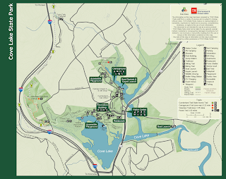
The Park & Trail Map
The Cove Lake State Park website describes the park as follows.
Cove Lake’s 606 acres are situated in a beautiful mountain valley on the eastern edge of the Cumberland Plateau. Scenic nature trails lead through a diversity of wetlands and woodlands offering wildlife viewing for the nature enthusiast. A paved walking/bike trail provides easy access to all park facilities. Visitors can spend the day fishing or simply sitting back and capturing the picturesque vista Cove Lake offers.
My 2006 Frontier got us to the visitor center, at 11:32 AM. I conversed with a park ranger, about the various trails. The “Printable Trail Map,” below, once enlarged to 200%, is readable in my web browser.
Our Hike, with Four Photographs
My “bionic” right foot did not want to pound the easy and “civilized” 3.5 mile “Paved Trail.” I thought that the 1.55 mile “Volunteer Trail (Loop)” -- to the far left or west, on the map -- might be sufficiently challenging for me and easy enough for my wife. To reach that trail head, from the visitor center, we drove 1.8 miles west, on US-25W N, to Bruce Gap Road (which the map identifies). My ol' truck was the only vehicle in the parking lot. We had the entire hike to ourselves!
We started our hike, at the information board, in the photograph below, at 12:11 PM. (Please note that all the photographs, in this article, were taken, as we hiked back out.)
Can you see the reflections of my wife and me, in the above photograph? Mrs. Appalachian Irishman, with a wave, was standing behind me. I was wearing a white T-shirt and my favorite hiking cap. The view looks northwest.
We'd hiked northeast, only a short distance, on a level trail, until we reached the main trail head, in the photograph below. The several trail options increased my interest in additional hikes!
Some years ago, a friend and former co-worker had mentioned the “Devil's Racetrack Trail.” Intrigued, I'd always thought that it would be a farther drive, from the house. After we'd been on the “Volunteer Trail (Loop)” a while, I noticed where the “Devil's Racetrack Trail” connected to it!
While Mrs. Appalachian Irishman waited, I hiked a short distance on the “Devil's Racetrack Trail!” It was somewhat interesting. I never did see the devil or his racetrack. I may call my friend, to see if he would like to hike the “Devil's Racetrack Trail” with me, one of these days!
The “Volunteer Trail (Loop)” is easy enough. It also intersects with the “Cumberland Trail,” on which we hiked awhile. Several switchbacks offered steep enough climbs, to challenge me a little. Going down other switchbacks was somewhat challenging. We saw many buckeyes, which had fallen from several buckeye trees. I brought two buckeyes home. If we'd had a sack with us, we could have picked a bag full!
At one point, we crossed a wooden bridge that spanned a small creek. Later, as we were on our way out, we spotted a turtle, apparently asleep, right on the trail. I tapped him, with my foot, and suggested that he get off the trail, before someone, not noticing, stepped on him more firmly. He didn't even stick out his head, to thank me for the warning!
The photograph below shows Mrs. Appalachian Irishman, waving, at the convergence of the “Volunteer Loop” and “Cumberland Trail.” This was at our hike out. Hiking in, we'd taken the right (southeast) fork, to the “Volunteer Loop.” We'd returned down the higher (northeast) “Cumberland Trail.” My hiking theology always states, “at a life crossroad, always take the right path, going in!”
A minute after I'd taken the above photograph, I used my “semi-intelligent” phone to record the podcast. The podcast is in the next section.
The next photograph is of the parking lot. As I've stated, this is on Bruce Gap Road, a short drive from the visitor center.
No other vehicle, aside from my ol' truck, was in the parking lot, at our arrival and departure. There's Mrs. Appalachian Irishman, waving at y'all again! My truck enjoyed the shade, while awaiting our return.
As an interesting note, we were near the parking lot and almost off the trail, when a local police officer drove in, around, and out of the parking lot! He must have been checking my truck. I hope that he saw us. I waved at him. If he'd stopped, I would have shaken his hand and thanked him for his service, to the folks in Caryville!
The “Volunteer Trail (Loop)” and adjacent trails are interesting enough. Interstate 75, maybe a tenth of a mile or so to the west, runs alongside much of the trail. I didn't care for all that traffic noise. Still yet, as I've said many times, “A day in the woods is better than not!”
For further reading, about the “Devil's Racetrack Trail,” this article suggests “Devil's Racetrack,” on Tennessee River Valley and, for a more personal article, “East Tennessee Hike: A Review of Devil’s Racetrack Trail to Triple Falls & Devil’s Overlook,” on "adventure and the girl," by Jayme, 3/19/2022. Both articles include great photographs. The first article summarizes the trail quite well. The second article, well written, is about a hike that the couple had taken last year. I like the personal style of the second article.
The Podcast, Featuring Mrs. Appalachian Irishman!
I started the video recording, at 1:10 PM, as I'd stated, below the third photograph -- where Mrs. Appalachian Irishman was waving, at the convergence of the “Volunteer Loop” and “Cumberland Trail.” It's only a minute and 32 seconds long, since I couldn't coax my wife into a more pithy conversation. I tried!
This Appalachian Irishman - Podcasts episode introduces, for the first time, and highlights Mrs. Appalachian Irishman! Take it away, dear! Here she is, folks: “Cove Lake State Park: 10-10-2023 Hike (published 10-12-2023; episode 20).”
Y'all are welcome, dear readers and viewers, to encourage my wife to open up her gift of gab a bit more, in her next podcast feature! She can and does talk more, when she sets her mind to it.
Dining at Rickard Ridge BBQ
Being hungry, after our hike, my wife and I decided to dine at Rickard Ridge BBQ, which is located in the park, just west of the visitor center. The cordial server (or waitress, as they were once called) seated us and took our orders quickly.
That had to be one of the best hamburgers that I've ever eaten! The french fries were great also! My wife enjoyed her loaded baked potato. We each ate every bite! I'd even thought about asking the diners, nearby, if I could have one of their mushrooms! Those looked good.
As the two photographs, below, indicate, the restaurant is quite nice. Large windows allow views of the valley, Cove Lake, and the Cumberland Mountains.
The next photograph looks northwest. The restaurant, to my southwest, is beside me. Enjoy the view!
Wouldn't you like to hike up to the ridge line, somewhere, on Cumberland Mountain? I would!
Conclusion
I wish, years ago, that I'd figured out that Cove Lake State Park is about the same distance, from the house, as Panther Creek State Park. I know now! My hiking log and memory recall three hikes, so far, at Panther Creek State Park: on 10/29/2010, as noted in “Four Hikes in Four Days! (published 11-14-2010),” on 11/24/2017, and on 12/10/2017. I have photographs and memories of the two hikes, in 2017, but I didn't publish articles about those hikes.
This hike was my 236th, since I started logging hikes, on 4/23/2000. Only the Good Lord knows the actual number of hikes that I've taken, before I started my log. It was Mrs. Appalachian Irishman's 28th hike with me. She's accompanied me on: House Mountain (12 of 181 hikes so far), Norris Dam State Park (three of 23 hikes so far), Hawkins County (one of 12 hikes so far), Smoky Mountains National Park (four of five hikes so far), and other locations (eight of 15 times so far). This hike is an “other locations” hike, in my hiking log.
Remember, dear reader, “Any day in the woods is better than not!” Today, the weather is clear, sunny, windy, and unseasonably warm. It would have been a good day for another hike. Mrs. Appalachian Irishman, however and unlike me, did not sense that “[t]he mountains are calling, and I must go” (John Muir, 1873). The source for the John Muir quote is noted in the articles of 3/31/2023 (House Mountain hike #179) and 4/14/2023 (House Mountain hike #180). My wife, bless her heart, doesn't hear the mountains call, as I do. To her credit, however, she did manage one hike in one week.
Well, this Appalachian Irishman is 10-10 on the side now. To any readers, who are interested in hiking House Mountain, I've hiked “My Mountain,” as I call it, 181 times, so far. If you'd like a free hiking guide, to help you on your first hike there, then you are welcome to use the “Contact Form,” on the main page of this website, to email me. I will respond!


No comments:
Post a Comment